Naming Everest
What the Origin of the World's Tallest Mountain's Name Reveals About the Politics – and Philosophy – of Naming Natural Landmarks in Colonial Contexts

Mount Everest—the name says it all. As the world’s tallest mountain, only a name that signifies its status as the greatest, the ultimate, and the most outstanding, will do. Those who visit agree: taking the shape of a symmetrical, three-sided pyramid, the mountain rises above a thicket of jagged peaks, distinguishing itself as an austere outlier. Its summit, forever frozen in snow and ice, penetrates Earth's stratosphere, occasionally catching passing cirrus clouds that fold to form a white wreath crown. Its rocky flanks are smoothed by eons of accumulated snow and ice, encasing it in a porcelain sheath. Instead of water, the mountain’s runoff is a massive glacier, kilometres long, that has carved a vast canyon through the surrounding peaks over millennia. Mount Everest—a poetic play on words that combines the adverb ‘ever’, signifying timelessness, with the superlative ‘est’. A name chosen to signify a mountain of eternal stature.
Or so it would seem. In fact, the name ‘Mount Everest’ was not chosen because the mountain was the tallest in the world. Instead, the true origin story reveals coincidence and colonial hubris as key causes. Nonetheless, the name is standard in Western discourse, even though most people around the world remain massively misinformed about its true meaning, as well as unaware of the long history of Tibetan and Nepali names that link the mountain to ancient myths and cosmologies of profound cultural significance. Given these shortcomings and contradictions, what accounts for the rigidity of the name ‘Mount Everest’? This may seem like an odd question, but it is one that was thoroughly explored by philosophers, particularly Saul Kripke, in the late 20th century and touches on the very nature of meaning itself. What’s more, through the lens of Kripke, we can derive important lessons about the complexities of naming natural landmarks in colonial contexts—a debate that persists in many regions of the world today.
The story of how Mount Everest was named, as summarized by John Keay in his book The Great Arc, begins at the turn of the 19th century, when the British East India Company’s influence was expanding in India. By this time, the Company controlled vast portions of the Indian subcontinent, including much of southeastern and northern India. Its primary motivation for establishing control was to exploit economic opportunities. By annexing large swaths of land and monopolizing the trade of goods such as cotton, silk, tea, and opium, the Company extracted massive wealth from India. Mapping became a key tool of this process, as it enabled the Company to document the country’s resources, including areas of agricultural production, which in turn informed tax revenue forecasts. So, in 1802, under the directive of the British East India Company, the Great Trigonometrical Survey of India was launched. A young infantry officer named William Lambton led a team of surveyors from Madras, a city on the eastern coast, setting out to measure precise distances between key landmarks across the subcontinent—with the ultimate goal of surveying the entire landmass.
Although land surveying in the early 19th century had recently seen significant advancements in technology and calculation methods, it remained a tedious and time-consuming process. A device called a Ramsden’s chain, a metal chain of 100 one-foot-long links, would be laid on the ground to measure the distances between two points in 100-foot-long sections. A second distance would be measured that connect a third point at an angle, which was determined using a theodolite—a device with a telescope mounted to a rotating circular stand. The theodolite was marked with fine angular divisions, allowing surveyors to document the angle between two points. The theodolites were heavy and cumbersome, requiring several men to carry them across the Indian plains, valleys, jungles, towns, and villages. Additionally, a device called a zenith sector was used to determine the latitude based on the point’s position relative to the pole star. Lambton relied on triangulation to calculate the third measurement; if the lengths of two sides of a triangle and one angle are known, the other distance can be calculated using basic trigonometry, essentially eliminating the need to measure the third distance by foot. The resulting map was a patchwork of triangles that stitched their way across the country from east to west. Most importantly, the lines that connected them were accurately scaled, making it the most precise surveys of India at the time.
The labour required to complete a full survey of the Indian subcontinent was immense, but the economic and scientific benefits were deemed well worth the effort. Toward that end, Lambton and his team worked their way across India, reaching Mangalore on the west coast in 1806. From there, they traveled south toward Cape Comorin, India’s southernmost point, before heading north toward their final destination: the Himalayas. This south-to-north corridor provided Lambton with the necessary distance to calculate an arc of the meridian—a segment of the Earth's circumference. By 1818, after more than a decade of work, Lambton and his team reached Hyderabad, a city near the centre of the Indian subcontinent. He had now crossed more than 700 miles (approximately 1,020 km), which translated to roughly 10-degree latitude of the Earth's surface. He continued northward from Hyderabad, but in 1822, after 20 years of surveying, Lambton fell ill and died just short of reaching Nagpur. Fortunately, a young and talented junior surveyor had joined Lambton’s team in Hyderabad and possessed the skills needed to succeed him as superintendent of the survey project. His name was George Everest.
Born in Wales in 1790, George Everest (pronounced ‘EVE-rest’) moved to India at the age 16 to work as a cadet for the British East Indian Company. Excelling in mathematics and astronomy, he was commissioned to survey the island of Java, which the British were in the process of taking control of from the Dutch. He returned to India in 1816, where he surveyed sections of the Ganges basin. Lambton took note of Everest’s work and decided to hire him as the chief assistant on the Great Trigonometric Survey. Everest joined Lambton in Hyderabad in 1818, and when Lambton passed away four years later, Everest was chosen to lead the project. By then, the survey was nearing the Himalayas, including the mountain that would eventually bear his name.
At this point in the story, one might expect a heroic tale of Everest overcoming impossible odds to survey the tallest mountain in the world—a story that would justify naming the mountain after him. But such a tale does not exist. In reality, Everest had very little involvement with mountain that would eventually bear his name. In fact, there is no evidence to suggest that George Everest ever visited the mountain—or even saw it.
Before concluding the story of how the world's tallest mountain got its name, it's important to explain how the name 'Mount Everest' challenges assumptions about how names, including names for natural landmarks, work. The first assumption is that they must describe features of the name referent. In some cases, the names for natural landmarks carry clear descriptions of landmark they refer to; that is, they have sense. For example, the town of Dartmouth in England is named for its location at the mouth of the River Dart. The name 'Dartmouth' carries concrete, descriptive meaning related to its geographical features. However, not all names for natural landmarks have such clear sense. Unlike Dartmouth, England, there is no River Dart in Dartmouth, Massachusetts. That doesn't mean the name lacks all sense, though. Its sense is more referential than descriptive, as it is believed to originate from explorers and settlers from Dartmouth, England, who named the new town in Massachusetts after their hometown on the other side of the Atlantic.
A common erroneous assumption about the name 'Mount Everest' is that it carries a descriptive sense—that the adverb 'ever,' signifying its supreme height, was combined with the superlative 'est.' In other words, people often think its name functions the same way as Dartmouth, England's name does, rather than the way Dartmouth, Massachusetts' name functions. But there is no evidence to suggest it was chosen to describe a unique feature of the mountain, such as its size. The fact that the name seems to poetically describe the mountain’s towering grandeur is the result of one thing and one thing only: coincidence.
This observation raises important questions about how names function, including those used for natural landmarks in colonial contexts. Specifically, are names meaningful because they evoke unique descriptions in our minds about the referent they represent? Or are they more like arbitrary tags that can be applied to any object, carrying no descriptive content? And if they are arbitrary, what makes one name ‘stick’ over other, competing names?
Questions like these were explored by the philosopher Saul Kripke in his 1980 book Naming and Necessity. At the time it was written, there was an ongoing debate among philosophers about the nature of names. John Searle, another philosopher working on proper nouns, had previously proposed a descriptive theory of names, which suggests that names evoke a mental cluster of descriptions that together ‘pick out’ a unique referent in the world. For example, the name ‘Aristotle’ evokes descriptions like ‘ancient Greek philosopher’, ‘student of Plato’, and ‘teacher of Alexander the Great’. By understanding these descriptions, we can identify the individual who satisfies all of them, thereby designating that individual as ‘Aristotle’. According to the descriptive theory of names, understanding the referent of a name always relies on mental reference, with the name functioning as an abbreviated version of the underlying cluster of descriptions.
Kripke disagreed with Searle’s descriptive theory of reference. In a series of lectures at Princeton, which he later compiled into his book, he used a thought experiment involving the name ‘Aristotle’ to highlight a flaw in this theory. Kripke reasoned that the descriptions commonly attributed to Aristotle, such as ‘ancient Greek philosopher,’ ‘student of Plato,’ or ‘teacher of Alexander the Great’, are not necessary truths. These descriptions are common in historical narratives, but that doesn’t mean they are unquestionable truths. It is possible that the person we refer to as ‘Aristotle’ was actually someone quite different. He may never have met Plato, taught Alexander the Great, or even spent any time philosophizing. It’s possible that, at some point in history, these descriptions were retroactively attached to the name ‘Aristotle’, much like how Napolean Bonaparte is often described as extremely short, despite being of average height for a Frenchman of his time. What’s critical, Kripke stressed, is that even if we dissolve all descriptions of ‘Aristotle’ into uncertainty, we can still refer to the person named ‘Aristotle’ as Aristotle. Therefore, there must be some mechanism other than description by which meaning is attached to names.
Before explaining what Kripke suggested that mechanism is, it’s important to draw a parallel between his thought experiment about Aristotle and the true story of how Mount Everest got its name. Much like the descriptors often attributed to Aristotle, many of the commonly held descriptions associated with Mount Everest can be challenged or disproven. The name was not chosen based on the mountain's height, and the man it was named after had no direct interactions with the peak. In fact, after succeeding Lambton as superintendent of the Great Trigonometric Survey in 1823, George Everest left India just two years later to return to England and recover from various health issues. He did not return to India for another five years. When he returned, he spent most of his time on project management and public relations matters, working from his home in Mussoorie, about 175 miles north of Delhi and far from the mountain that would eventually bear his name. From his home office, Everest oversaw the completion of the Great Trigonometric Survey, returning to England for the final time in 1843 to retire. It wasn’t until 1852, nearly ten years after Everest left India, that Radhanath Sikdar, an Indian mathematician from Calcutta working on the Great Trigonometric Survey, calculated the height of Mount Everest, then called Peak XV, to be 29,000 feet, the tallest ever measured in the world. It’s worth noting that Sikdar’s calculation was astoundingly accurate given the rudimentary technology available at the time. In 2020, a survey using advanced GPS and satellite technology measured the mountain’s height at 29,032 feet—placing Sikdar’s 1852 calculation within a tenth of a percent of the modern figure.
At the time of Sikdar’s measurement, British surveyors commonly used local or native names for geographical features. In fact, in 1856, two years after Sikdar’s work, Andrew Scott Waugh gave a speech to the Royal Geographical Society, the organization responsible for naming geographic entities for Western academic audiences. In his speech, Waugh noted that his predecessor, Everest, supported the use of native names in maps, stating:
“I was taught by my respected chief and predecessor, Colonel Sir George Everest, to assign to every geographical object its true local or native appellation. But here is a mountain, most probably the highest in the world, without any local name that we can discover, whose native appellation, if it have any, will not very likely be ascertained before we are allowed to penetrate into Nepal and to approach close to this stupendous snow mass.”
Waugh’s last remark alluded to Nepal’s ban on foreign visitors—a policy that remained largely in place until the 1950s. Unaware of any local or native names for the mountain, he proposed an alternative, stating:
“… to perpetuate the memory of that illustrious master of accurate geographical research, I have determined to name this noble peak of the Himalayas ‘Mount Everest.’”
But the proposed name was not without controversy. George Everest himself, then living in Hyde Park, London, objected to the choice. He argued that his surname was difficult for locals to pronounce and could not be easily written in Hindi. Despite his objections, Waugh’s proposal prevailed. In 1865, more than a decade after Sikdar’s calculation and over twenty years after Everest had left India for the last time, the Royal Geographical Society officially named Peak XV after a man who had no direct connection to the mountain.
Nonetheless, the name Mount Everest has endured. Its persistence can be explained through the framework Saul Kripke proposed in response to John Searle’s descriptive theory of reference. In his rebuttal, Kripke introduced the causal-historical theory of naming, which claims that names refer to objects in the world not through descriptive content or conceptual meaning, but directly—independent of any associated sense or characteristics. Names, according to the causal-historical theory, are fixed to their referents by some original act of naming—what Kripke called the "initial baptism" of an object. From this point onwards, the name rigidly designates the object regardless of any descriptive information associated with the named object. In this way, a person using a name doesn’t need to know a unique description of the object it refers to. Instead, they simply need to use the name in the same way it was used during the original act of naming. This use is preserved and transmitted through a historical chain of consistent reference within a community of speakers.
The common erroneous assumption that the name 'Mount Everest' carries descriptive sense about the mountain’s stature highlights the central claim of the causal-historical theory of names: that description is ultimately irrelevant to reference. Similarly, the disparate association between the mountain and the man himself, Sir George Everest, further emphasizes that naming is more a matter of might than accuracy. Once the Royal Geographical Society “baptized” Peak XV as Mount Everest, the name entered into an expansive and influential community of speakers. Through continued use, this community created a kind of positive feedback loop that reinforced the link between name and referent. Over time, the name became rigid—firmly fixed to the mountain itself and immune to distortion by erroneous or intermediary descriptions.
Examining the naming of Mount Everest through Kripke’s theoretical lens reveals important lessons about the complexities of naming natural landmarks in colonial contexts. These names don’t need to carry any descriptive content to become rigid or widely accepted. All that’s required is an initial act of naming, the “baptism”, and a community of speakers influential enough to ensure its continued use and proliferation. In this way, naming within colonial contexts becomes a kind of linguistic power grab, where imposed names overwrite and often erase local or native ones.
In geopolitics, disputes over the naming of natural landmarks are often seen as bellwethers for deeper tensions—even potential armed conflict. The 3.5 million square kilometer stretch of ocean flanking Southeast Asia through which over $3.36 trillion in global trade flows is among the most hotly contested regions in the world, with multiple surrounding nations asserting competing claims of authority. Naming has become a strategic tool for asserting authority, with each nation assigning spatial designators to the waters based on its own geographic perspective. The Philippines refers to this expanse as the West Philippine Sea, Vietnam calls it Biển Đông (East Sea), and Indonesia has named a portion of it the North Natuna Sea. For China, and much of the Western world, the area is known as the South China Sea. Indeed, while each country maintains economic, cultural, and historical ties to the waters, naming is not used to describe this shared reality. Instead, it is employed as a means of advancing national interests and reinforcing territorial claims, often with direct influence on diplomacy and policy decisions.
In some cases, the names of natural landmarks are so unrelated to the landmark’s features themselves that they border on the absurd. The most widely accepted origin story of the name "Yucatán" suggests it came from a misunderstanding between early Spanish colonizers and the Mayans. When the Spaniards asked the locals the name of the region, the Mayans replied, “Ma'anaatik ka t'ann,” meaning “I don’t understand.” Similarly, the most widely accepted explanation for the name "Madagascar" is that it originated from a misunderstanding by the 13th-century Venetian explorer Marco Polo. In his memoirs, he confused the island with the East African port city of Mogadishu, referring to it as "Madageiscar", which was likely a corrupted form of "Mogadishu." In both cases, these absurd interpretations of local languages stuck, and few of us ever question what these names actually mean. All it took was a community of speakers, backed, in many cases, by colonial power, who were influential enough to impose the name into common use.
In the face of such arbitrariness and absurdity, it’s worth asking what is lost when local or Indigenous names for natural landmarks are replaced by those imposed through colonial power. Despite Waugh’s own claim that no local or native name could be found for Peak XV, several already existed. In Nepal, Peak XV was known as Sagarmāthā, meaning “the head in the great blue sky.” The name personifies the mountain, seen as a sacred bridge between the earthly realm and the divine, particularly by the Sherpa people of Nepal. In Tibet, the mountain is called Qomolangma, meaning "Holy Mother" or "Goddess Mother of the World." The name reflects Tibetan Buddhist beliefs, which revere the mountain as a protective deity with the power to purify the mind and soul. Both the Nepali and Tibetan names root the mountain in the religious traditions of their respective cultures, each with histories stretching back for more than a thousand years. What’s more, this cultural and spiritual significance can influence modern policy decisions. While climbing Mount Everest is permitted, nearby Mount Khumbila, which is believed to be the dwelling place of a local deity, is considered too sacred to ascend. In Bhutan, mountaineering on peaks above 6,000 meters (about 20,000 feet), which are often named after or associated with deities and spiritual beings, is completely banned out of respect for their religious significance. This includes Gangkhar Puensum (meaning "White Peak of the Three Spiritual Brothers"), which, at 7,570 meters (24,836 feet), remains the highest unclimbed mountain in the world. Climbing Mount Kailash, a sacred mountain in western Tibet revered by Hindus, Buddhists, Jains, and Bon practitioners, has been prohibited since mountaineers first attempted to explore it in the 1930s. In the mid-1980s, when the Italian mountaineer Reinhold Messner was given the opportunity by the Chinese government to climb Mount Kailash (translated to “Crystal Mountain”), he reportedly declined, saying, “If we conquer this mountain, then we conquer something in people’s souls.” Messner recognized the deep cultural significance of Mount Kailash, but it’s worth asking whether that would have been the case if the mountain had been named otherwise, especially one imposed by a colonial authority.
In contexts where colonial names persist, challenging these naming conventions can serve as a means to confront and resist colonial power, while also redirecting attention toward indigenous narratives. In the 1960s, the Nepali government officially adopted and promoted the name Sagarmāthā to reassert Nepali cultural influence over the mountain, and it continues to use the name on official certificates recognizing successful ascents. In colonial countries like New Zealand, Australia, Canada, and more recently the United States, public events often begin with land acknowledgements that name and honor Indigenous lands, reinserting these names and their histories into public discourse. These land acknowledgements were hard-won by Indigenous activists. In Australia, they gained prominence following the decade-long legal battle of the Mabo case, in which the High Court of Australia recognized the existence of native title, a collection of rights that Aboriginal and Torres Strait Islander peoples have to land and waters they have historically occupied. In Canada, land acknowledgements became more widely adopted after the release of the Truth and Reconciliation Commission report, a six-volume document that outlines the history and impacts of the cultural genocide committed by Canada’s residential school system, which operated from the 17th century until the late 1990s. Through land acknowledgements, we expand and strengthen what Kripke called a community of speakers, now aware of and able to use Indigenous names, cleaving the causal-historical chain of colonial names and uncovering layers of Indigenous cultural histories and social identities that stretch back to a time long before colonization. In this way, naming becomes not an act of oppression, but an act of emancipation.
Despite this progress in recognizing local and Indigenous names for natural landmarks in colonial contexts, many countries around the world still grapple with the ongoing tension between colonial naming conventions and Indigenous place names. In Alaska, Mount Denali, which rises dramatically from a flat river basin into a massive, multi-peaked mound reaching 20,156 feet (6,144 m) above sea level, was renamed Mount McKinley by an executive order from the Trump administration, a move widely seen as an appeal to his conservative nationalist base. This, despite the fact that, like Sir George Everest, William McKinley never saw the mountain that would bear his name. He never visited Alaska, and he wasn’t even president when his name was first proposed. The name was suggested by a gold prospector from New Hampshire, who introduced the peak to the American public in an 1897 article in The New York Sun, naming it “Mount McKinley” in honor of McKinley, then the Republican presidential nominee, for his support of the gold standard, an economic policy that directly benefited gold prospectors. In contrast, the name Denali (meaning “the High One”) comes from the Koyukon, the Indigenous people who have lived in the region for over a thousand years. They view the mountain as a living spiritual entity deeply connected to Native Alaskan cultural and religious traditions. How can we adjudicate between colonial names and existing Indigenous names for natural landmarks?
The story of the origin of Mount Everest’s name, viewed through Kripke’s theoretical lens, teaches us that naming has little to do with sense or description and everything to do with power. That is, unlike other types of words, names do not derive their meaning from directly identifying the irreducible elements or history of the named referent. Instead, they absorb their meaning through a historical chain of shared use within an influential community of speakers. In this way, it is up to the community of speakers to critically assess whether the names they assign to natural landmarks truly reflect the most meaningful and authentic historical narratives. In some cases, like that of Mount Everest and Mount McKinley, the colonial names used for natural landmarks have little historical connection and absolutely no descriptive sense. But through collective effort, including land acknowledgements, we can break these causal-historical chains of erroneous colonial names, reasserting Indigenous names and their associated cultural and historical significance.
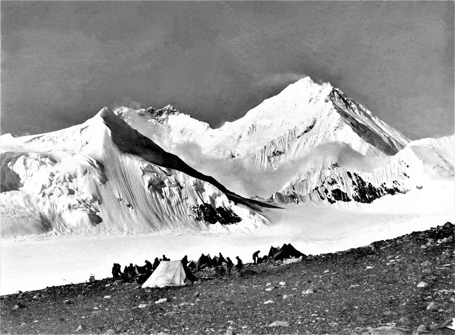
Photograph by Howard Somervell on the final day of the 1921 Reconnaissance Expedition of Mount Everest, showing Camp 2 at 19,000 ft.